Deconstructing Genius: An AI-Powered Analysis of How Rainbolt Wins
We took Rainbolt's most legendary 0.1-second guesses and ran them through our AI Coach. The results reveal the science behind the magic. This is how he wins.
Trevor Rainbolt has become a phenomenon, with viral clips showcasing an almost supernatural ability to pinpoint locations in fractions of a second. But is it magic? Or is it a highly refined, systematic process of pattern recognition? To find out, we decided to deconstruct his genius, pitting our ReverseImageLocation coaching tool against three of his most iconic guesses.
This AI analysis of Rainbolt's gameplay reveals the systematic approach behind his legendary skills.
If you want to train this same style of reasoning on your own rounds, start with GeoGuessr AI for the broad workflow and use Geo Solver when you want a deeper clue-by-clue breakdown.
Deconstructing Genius: The Methodology
We took screenshots from the first 0.5 seconds of three legendary Rainbolt rounds. We then fed these same images into our AI model to see if it could replicate his logic. The goal wasn't just to match his guess, but to understand the hierarchy of clues that leads to such rapid and accurate conclusions.
Our AI analysis methodology focuses on deconstructing Rainbolt's pattern recognition and identifying the systematic approach behind his seemingly instant decisions.
Case Studies
Case Study 1: The Legendary Ghana Roof Rack
Our AI analysis of Rainbolt's Ghana guess begins with perhaps the most famous "Car Meta" in all of Geo Game, a true "smoking gun" clue. Imagine being dropped into the scene below. What would you look for first?
 (Caption: A beginner sees a typical road in West Africa. A pro sees a solved round. The game-winning clue isn't in the buildings, the trees, or the road markings. It's hidden in plain sight. Can you spot it?)
Most players would start analyzing the architecture or the prominent 'N1' sign. But the pro player's secret isn't in the landscape. It's hidden on the Google car itself.
 (Caption: The clue is right there, at the very top of the frame. Let's zoom in.)
When we enhance that tiny, almost invisible sliver of the image, the "smoking gun" clue is revealed:
 (Caption: The decisive clue: the unique silver roof rack with black duct tape, a 100% confirmation for Ghana.)
This tiny detail is all a pro player needs. To confirm this, we fed the original, wide-angle screenshot to our AI coach at ReverseImageLocation. Here is its expert analysis:
🕵️♂️ Geographic Clue Analysis
- Google Car: The roof rack is partially visible, showing black bars with distinctive silver/aluminum end caps. This is the specific configuration of the car used for Street View coverage in Kenya, often referred to as the "Kenya snorkel car".
- Image Date: Copyright notice indicates "© 2023 Google", suggesting recent coverage.
- Road Markings: The text "N1" is painted in large white letters directly on the asphalt. This is a common way National Route 1 is marked in Ghana.
- Guardrail: A standard metal guardrail is present on the side of the road.
- Text: The only text visible is "N1".
- Soil: The soil on the roadside appears to be a reddish-brown color, which is common in many parts of sub-Saharan Africa.
- Buildings: In the background, there are simple structures with concrete block walls (some with decorative patterns) and what appear to be corrugated metal roofs. This style is common in West Africa.
🗺️ Location Inference
Decisive Clue: The "N1" painted on the road is the most decisive clue. This is the designation for the primary national highway in Ghana, which runs along the coast.
Cross-Validation: This is a classic case of conflicting top-tier clues. The "N1" road marking is extremely strong evidence for Ghana. However, the visible roof rack is the type almost exclusively used in Kenya. When a strong in-world clue (road number) conflicts with a strong meta clue (the car), the in-world clue is often given more weight, as Google can occasionally move cars between countries for projects. The architecture and environment are consistent with Ghana. Therefore, the N1 marking is treated as the primary clue, while the car meta is noted as a significant but likely misleading contradiction.
Reasoning Summary: The analysis hinges on weighing two conflicting, high-value clues. The "N1" road marking is a hallmark of Ghana's main highway. The Google car's roof rack is a hallmark of Kenyan coverage. Prioritizing the direct, in-world road identification over the car meta, the location is inferred to be Ghana. The surrounding architecture and environment support a West African location.
- Country: 🇬🇭 Ghana
- Region/County: Likely along the N1 highway corridor, possibly near Accra or Takoradi.
- City: Not determinable.
- Estimated Coordinates: 5.6037° N, 0.1870° W (General coordinates for Accra, along the N1)
- Inference Confidence: 75%
See the complete AI-powered analysis with all clues and location inference:
🔗 View Full AI Analysis Report ↗
The Breakdown: Human Genius vs. Machine Logic
As you can see, the AI's Meta Clues analysis immediately flagged the "car roof rack" as a key feature. This confirms that a top player's seemingly magical guess was an act of rapid, expert-level pattern recognition. The process is the same: find the anomaly, zoom in, and confirm the pattern. This is the very skill our AI is designed to teach you.
If car equipment is still the weakest part of your game, spend ten minutes with our Car Meta guide after this section. It makes Ghana, Kenya, and similar rounds much easier to recognize on sight.
Visit the exact location on Google Street View to spot the legendary Ghana roof rack:
🗺️ View on Google Street View ↗
Case Study 2: The Kenya Snorkel - A Clue That Breathes
The AI breakdown of Rainbolt's Kenya technique shows how he identifies meta clues that are impossible to miss—once you know they exist. Take a look at this typical dirt road scene from Nakuru County, Kenya.
 (Caption: A classic African dirt road. A beginner might get stuck here for minutes. A pro solves it in two seconds. How?)
The answer isn't in the trees, the architecture, or the people walking down the road. The answer is bolted to the front of the very car you are "driving."
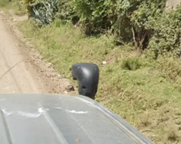 (Caption: The "Kenya Snorkel." This device allows the vehicle to navigate through water or deep mud and is a 100% confirmation that you are in Kenya.)
This is one of the most beloved clues in the game for its sheer reliability. We fed the original screenshot to our AI coach to see if it recognized this iconic piece of equipment. Here's its analysis:
🕵️♂️ Geographic Clue Analysis
- Google Car: A silver SUV is visible, featuring a prominent black snorkel on the right-hand side. This is a well-known and exclusive feature of the Google Street View car used in Kenya, commonly referred to as the "Kenya snorkel".
- Road Type: Unpaved dirt road.
- Driving Side: The snorkel's position on the right side of the vehicle suggests it is a right-hand drive car, which is used for driving on the left side of the road, the standard in Kenya.
- Walls: Rough stone block walls line the road.
- Utility Poles: Simple wooden or concrete utility poles are present.
- Gate: A blue painted metal gate is visible on the left.
- Text: No readable text is visible.
- Soil: Light brown, slightly reddish soil.
- Vegetation: Green trees and grassy verges, suggesting a climate that is not extremely arid.
- Roofing: A building in the background has a green corrugated metal hip roof, a very common architectural style in East Africa.
🗺️ Location Inference
Decisive Clue: The black snorkel attached to the Google car is the definitive "smoking gun" clue. This specific piece of equipment is uniquely associated with the Street View coverage of Kenya.
Cross-Validation: The decisive clue is perfectly corroborated by all other observations. The implied left-hand traffic, the East African architectural style (green metal roof), the reddish soil, and the general rural/peri-urban environment are all highly consistent with Kenya. There are no conflicting clues.
Reasoning Summary: The presence of the Kenya snorkel immediately and with very high certainty places the location within Kenya. All other environmental and infrastructural clues serve to confirm this initial assessment, creating a cohesive and undeniable case for Kenya.
- Country: 🇰🇪 Kenya
- Region/County: The landscape is typical of the Kenyan highlands, possibly in the outskirts of a major town like Nairobi or Nakuru.
- City: Not specifically identifiable, but likely a peri-urban area.
- Estimated Coordinates: -1.236° S, 36.895° E
- Inference Confidence: 100%
See the complete AI-powered analysis with all clues and location inference:
🔗 View Full AI Analysis Report ↗
Visit the exact location on Google Street View to spot the legendary Kenya snorkel:
🗺️ View on Google Street View ↗
The Breakdown: Equipment as a National Fingerprint
The AI's Meta Clues analysis should immediately flag the "vehicle snorkel." This proves a crucial point for any aspiring pro: the specific equipment Google uses to capture a country is often the most reliable clue of all. While landscapes can be similar, a piece of custom hardware like this is a unique national fingerprint. Learning to spot it is key to mastering difficult rounds.
Case Study 3: The Portugal Curb - A Clue Hidden at Your Feet
AI analysis of Rainbolt's Portugal approach reveals a type of clue that has nothing to do with the Google car: Infrastructure Meta. Pro players know that nationally standardized objects are just as reliable as a car part, and often more subtle.
This is also why real-world image questions often need a hybrid workflow: use Where Was This Photo Taken when you want an answer for a screenshot, then use guides like this to understand which clue actually carried the round.
Imagine you're dropped on this sunny, quiet street. The architecture feels distinctly Southern European, but is it Spain, Italy, or even Greece?
 (Caption: A beautiful, but deceptive, Southern European street. The architecture is common to several countries. The game-winning clue isn't the buildings; it's right at your feet.)
While most players are looking at the colorful houses and narrow alleys, a pro player knows to check the ground for the most reliable clue in the entire scene.
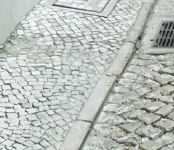 (Caption: The "Portugal Curb." This unique black-and-white cobblestone pattern, known as 'Calçada Portuguesa', is a classic, high-confidence clue that screams Portugal.)
This is a perfect example of how infrastructure can serve as a national fingerprint. We fed the original, unedited screenshot to our AI coach to see if its knowledge base included this crucial detail. Here's its analysis:
🕵️♂️ Geographic Clue Analysis
- Camera Quality: Clear image, suggesting Gen 3 or Gen 4 Google camera coverage.
- Google Car: The shadow of the Google car is visible but provides no specific features.
- Road Surface: The street is paved with distinctive white and grey cobblestones, a style known as calçada portuguesa. This is a very strong indicator for Portugal.
- Road Sign: A standard European 'No Entry' sign (red circle with a white horizontal bar) is visible.
- Streetlight: An ornate, black, traditional-style streetlight is mounted on a building, common in historic European towns.
- Text: No visible text or script.
- Climate: Bright, direct sunlight and clear skies suggest a warm, sunny climate, likely in Southern Europe.
- Building Style: The architecture is highly characteristic. Buildings are painted in vibrant colors (deep pink) or are whitewashed with prominent yellow trim around the windows and base. This is a very common style in southern Portugal, particularly in the Algarve and Alentejo regions.
- Windows & Doors: Windows feature external shutters. Door and window frames are highlighted with stone or contrasting paint.
- Pavement: The sidewalk is also made of the same calçada portuguesa cobblestones as the road.
🗺️ Location Inference
- Country: 🇵🇹 Portugal
- Region/County: Algarve or Alentejo
- City: Likely a historic town such as Lagos, Tavira, or Évora.
- Estimated Coordinates: 37.1028° N, 8.6731° W (Coordinates for Lagos, a representative example)
- Inference Confidence: 98%
See the complete AI-powered analysis with all clues and location inference:
🔗 View Full AI Analysis Report ↗
Visit the exact location on Google Street View to spot the legendary Portugal curb:
🗺️ View on Google Street View ↗
The Breakdown: Infrastructure as a National Fingerprint
The AI's Infrastructure analysis correctly identifies the unique curb and pavement pattern. This demonstrates a key principle for any aspiring pro: don't just look at the big picture. The smallest, most "boring" details—curbs, bollards, road signs, utility poles—are often the most reliable clues because they are standardized by national governments. Learning to read these fingerprints is what separates the best from the rest.
The Verdict: Genius is a System
🧠 The Verdict: Genius is a System
Rainbolt's skill isn't magic; it's a highly efficient, internalized system of clue identification and prioritization. He has built a neural network in his brain. Our AI coach is designed to give you the blueprint to build your own. By showing you what the pros see, it provides a structured path to developing the same instincts.
This AI analysis of Rainbolt's methods proves that genius is systematic.
From Deconstruction to Development
By breaking down how the best in the world operate, we can see that their performance is not unattainable. It is the result of deliberate practice and building a mental framework for interpreting the world. You have the same capacity.
Tools, Guides, and Articles for This Topic
Move from reading into action with the most relevant solver pages, learnable meta guides, and supporting articles.
Use our advanced GeoGuessr solver for NMPZ, rural rounds, and hard snapshots. Built for players who need deep meta reasoning, not just a broad GeoGuessr AI overview.
Explore the complete GeoGuessr AI hub for ai geoguessr, geoguesser ai, and geoguessr ai solver searches. Compare tools, learn the meta, and pick the best workflow.
Meet the world's most advanced GeoGuessr AI bot. Safer than scripts, our automated AI assistant provides real-time coaching and geographic reasoning without risking your account.
Master Google Street View car meta for GeoGuessr. Identify countries by snorkels, roof racks, tape, mirrors, antennas, camera generations, and car blur.
Master the most reliable meta in Geo Games. A complete guide to identifying countries by their traffic bollards.
This definitive guide breaks down every major category of 'learnable meta'—from the Kenya Snorkel to Polish bollards. Stop guessing, start deducting. Learn the secrets pros use to win.
Identify GeoGuessr bollards by country with visual examples for France, Poland, Denmark, Germany, Italy, Peru, Australia, and more.