Cardify - Mistake Scan
Scan mistakes into organized study records with AI-powered solutions and feedback.
Upload a photo, picture, or screenshot and use AI to find its likely location from visible clues. Works without GPS metadata, EXIF, or an indexed reverse image match.
Use a camera photo, saved image, screenshot, or social media download.
Find photo location from visual evidence when EXIF metadata is missing or stripped.
Get a likely country, region, or place with the clues that supported the answer.
Tools and apps you might also like.
Scan mistakes into organized study records with AI-powered solutions and feedback.
Turn voice notes into tasks, reminders, and clean daily plans in seconds.
AI health companion for readiness, recovery, sleep, load, and life context.
Track expenses with voice input, receipt scan, and quick spending insights.
This page is built for the exact task: find photo location AI. Upload an image and GeoSolver uses AI to read the visible evidence that can reveal where it was taken.
It works best for searches like:
The workflow is different from a normal reverse image search. Instead of only looking for the same image on the web, the tool reads geographic clues inside the photo: road markings, architecture, vegetation, terrain, signs, vehicles, bollards, utility poles, and lighting.
| Your search intent | Best page |
|---|---|
| "find photo location AI", "find photo location", or "photo location finder" | Stay here |
| "where was this photo taken" | Where Was This Photo Taken |
| "reverse image search location" | Reverse Image Search for Location |
| "where is this picture from" | Where Is This Picture From |
| "where is this image from" | Where Is This Image From |
Use a JPG, PNG, WebP, screenshot, or downloaded social image. The image does not need to contain GPS metadata.
GeoSolver checks clues that often survive cropping, compression, and social media reposting:
The result gives a likely location, a confidence level, and a readable explanation. You can use that evidence to verify the place manually or narrow the search area.
Many people try to find a photo location by checking EXIF data first. That can work for original camera files, but it often fails because social apps, messaging apps, screenshots, and downloaded web images usually remove GPS fields.
This tool focuses on the pixels that remain. A useful image does not need coordinates embedded in the file. It needs visible context.
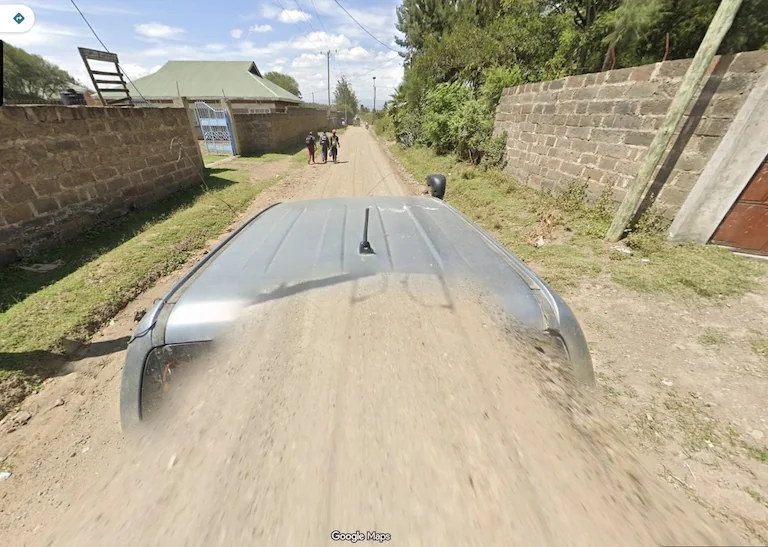
This kind of image can be hard for ordinary reverse image search, but the road, soil, vegetation, and vehicle clues still support a location estimate.
Photos with outdoor context usually perform best. Good candidates include travel photos, road scenes, street screenshots, city views, landscapes, storefronts, and social posts with visible background detail.
Images with only a face, a plain wall, a close-up product, or a heavily blurred background may not contain enough geographic evidence.
Most people should start here: upload the photo and let GeoSolver estimate the place from visible clues.
Use a more specific page when your task has a different shape:
GeoSolver returns more than a single guess. A useful result should include:
| Output | Why it matters |
|---|---|
| Likely country or region | Gives you a starting area instead of a blind search |
| Visible clues | Shows which parts of the image influenced the estimate |
| Reasoning | Explains how road, landscape, sign, vehicle, or architecture clues connect to a place |
| Confidence language | Helps you decide whether the result is strong, medium, or only a rough lead |
| Verification next steps | Points you toward maps, satellite imagery, reverse image search, or local reference photos |
For a broader comparison of tool choices, see Best Reverse Image Location Tools.
| Strong for photo location | Weak for photo location |
|---|---|
| Outdoor roads, streets, storefronts, mountains, coastlines, signs, and landscapes | Plain walls, selfies, close-up objects, heavily blurred backgrounds, and studio photos |
| Multiple independent clues in one frame | One vague clue with no surrounding context |
| Natural light, road context, architecture, and terrain | Cropped images that remove the useful background |
If the image is weak, crop toward the most geographic clue and try again. A small sign, unusual road marking, coastline, mountain shape, or utility pole can be more useful than the main subject.
Treat the AI location as a hypothesis. Check whether the strongest clues agree with each other, then compare the candidate area with maps, satellite imagery, Street View, local photos, and reverse image search results. For a complete checklist, read How to Verify AI Image Geolocation Results.
You can try any image, but the result depends on visible location clues. Outdoor scenes, roads, buildings, signs, landscapes, and travel photos are much stronger than close-ups or blank indoor images.
AI looks for visible geographic clues such as road markings, vegetation, architecture, soil, signs, vehicles, and terrain. GeoSolver combines those clues into a likely country, region, or place estimate with readable reasoning.
No. GPS metadata can help when it exists, but this tool is designed for images where metadata has been stripped or was never available.
No. Traditional reverse image search looks for matching copies online. GeoSolver estimates location from the content of the image itself, so it can still help when the photo is unique.
Crop to the most useful clues and try again. Road signs, shopfronts, lane markings, bollards, mountains, coastlines, and unusual architecture often improve the estimate.
Use Where Was This Photo Taken for question-style searches, or Reverse Image Search for Location if you are comparing this workflow with Google Lens, TinEye, or other image-search tools.
Continue this topic with the most relevant tools, learnable meta guides, and supporting articles.
Upload a photo, picture, or screenshot and find where it was taken. GeoSolver reads visual clues when EXIF, GPS metadata, or Google Lens matches are missing.
Use reverse image search for location when Google Lens, TinEye, or EXIF fails. Upload a photo and find where it was taken from visual clues.
Upload a web image, repost, or screenshot to find where it is from. Useful when reverse image search gives links but not clear source context or location.
Master the most reliable meta in Geo Games. A complete guide to identifying countries by their traffic bollards.
Master Google Street View car meta for GeoGuessr. Identify countries by snorkels, roof racks, tape, mirrors, antennas, camera generations, and car blur.
Compare free Picarta alternatives for photo geolocation, screenshots, image location finding, reasoning quality, and pricing.
Grok can analyze uploaded images, but it is not a Google Lens-style reverse image search index. See what works, what fails, and the best workaround.
Identify GeoGuessr bollards by country with visual examples for France, Poland, Denmark, Germany, Italy, Peru, Australia, and more.
Our AI analyzes visual clues to estimate where the image was taken
Drag, paste, or click to upload your image